Australia Weather News
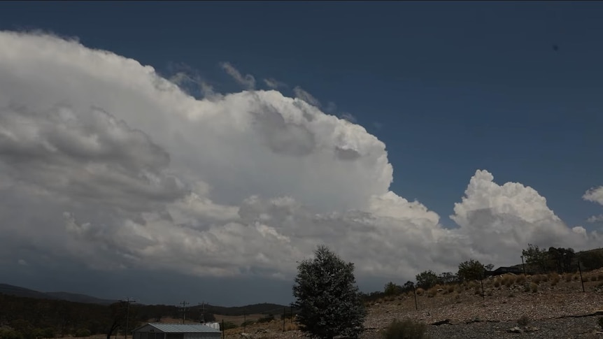
A storm builds over south-east NSW on Wednesday as an outbreak flared up over the state's east. (Supplied: Farmer Boads)
After last week's extreme heatwave and devastating bushfires, a major shift in the weather pattern will help deliver a week-long drenching to Australia's eastern seaboard.
However, while the return of rain and thunderstorms will assist in lowering the short-term fire threat, the summer soaking also has the potential to generate both flash and river flooding.
In the meantime, ex-Tropical Cyclone Koji continues to dump rain over tropical Queensland, while a new tropical low and area of flooding could emerge over the Top End this weekend.
Severe thunderstorms for NSW and VIC, followed by flooding rain
The most significant drenching in months is ahead for eastern parts of NSW and Victoria.
Rain began on Wednesday as scattered thunderstorms fired up over central and south-east NSW, and by 6pm, 39 millimetres had fallen in Cudal, just west of Orange.
The storm outbreak will intensify and expand on Thursday as an inland trough deepens, stretching from south-west Queensland, through eastern NSW to most of Victoria.
Severe thunderstorms are likely in all three states along with the ACT, including the risk of heavy falls and flash flooding.
East Gippsland, the south-east corner of NSW and along the state's northern slopes and ranges are at the greatest risk.
The biggest thunderstorm threat on Friday will extend across central east and north-east NSW, however a bit of steady rain and the odd storm should also develop along the south coast and through Gippsland, Victoria.
This region of heaviest rain, along with a burst of strong winds, is then predicted by modelling to shift slowly up the coast through the weekend to be focused around the Illawarra, Sydney and the Hunter by Sunday — and again there is the risk of some flash flooding.
The combination of the initial thunderstorms, the rain to follow and further showers next week should boost weekly totals to above 50mm along the coast and eastern ranges from the Queensland border to West and South Gippsland.
Totals from Sydney to East Gippsland may average in the range of 100 to 200mm and could even hit the 200 to 300mm range on pockets of the NSW south coast.
While flash flooding is possible in multiple districts, the risk zone for river flooding is mostly confined to the Illawarra and south coast, and thankfully minor flooding is currently the favoured outcome due to relatively dry catchments.
The sudden shift in the weather is due to the location of high-pressure systems — a high was positioned unseasonably north off the coast of Sydney last week, and since winds blow anticlockwise around a high, this resulted in a hot and dry north-westerly airstream across south-east states.
This week, a high-pressure cell will track below Tasmania and direct humid onshore winds onto the east coast, providing the moisture to fuel the rain and thunderstorms.
Short-term fire threat reduced, but far from over
While rainfall reduces the intensity and spread of a bushfire, it takes a significant amount of precipitation for a large fire to be completely extinguished — sometimes more than 100mm since burning can continue underground in roots, and on the inside of logs and trunks.
However, typically after a good solid soaking of at least 30 to 50mm, a fire can be contained, at least in the short-term before dry weather returns.
The most efficient type of rain for slowing a blaze is steady solid falls over several days which can soak into the ground and increase fuel moisture, while short sudden downpours simply run off into creeks and rivers.
However, rainfall can also hamper efforts to contain or extinguish a fire by dampening the vegetation enough to prevent back-burning.
So how much rain will fall over the Victorian fire grounds this week?
The Dargo fire could receive more than 50mm, while the Longwood and Shire of Towong fires could see anything from about 5 to 20mm.
For fire grounds in western Victoria the average fall will range from nothing to just a few millimetres which will have little-to-no impact, although a second burst of showers and storms early next week could bring further relief.
Another factor which complicates the short-term fire threat is wind, which will strengthen from Thursday and could gust to around 80 km/h for several days, resulting a 'high' fire danger for much of Victoria despite the relatively humid weather.
New flood threats emerge from northern wet season
Flooding rains are also likely this week across parts of tropical Australia as the monsoon trough returns.
Ex-Tropical Cyclone Koji continues to drift slowly north-west over northern Queensland, but has carried a substantial amount of moisture inland on its southern flank.
The system has already dumped well over 200mm over parts of the Central Highlands, Central Coast and Capricornia since the weekend, in some cases well over double the monthly average.
While widespread heavy rain has now eased, the remnants of Koji will still trigger localised heavy rain and flash flooding from the Gulf Country to the Central Coast on Thursday.
Heavy downpours from thunderstorms will persist over a similar region on Friday, before the heaviest rain shifts mostly to Cape York Peninsula this weekend.
Along with the risk of flash flooding, a flood watch for 15 rivers and creeks remains for the Gulf Country and parts of Western and Central Queensland along with the Cape York Peninsula.
The remnants of Koji may drift out over the warm seas of the Gulf of Carpentaria this weekend or early next week, however the chance of re-development into a cyclone is rated at or below 15 per cent by the Bureau of Meteorology until at least next Wednesday.
However, as the threat gradually eases across Queensland, a new tropical low is likely to form over the Top End.
While over the inland, there is no risk of a cyclone forming, however 24-hour totals both Saturday and Sunday could exceed 100mm in parts of the Top End, possibly including around Darwin.
This next system is forecast by modelling to drift west off the coast early next week, leading to a 25 per cent chance of cyclone development by midweek off the WA north coast.
ABC