Weather Warning
IDV21137
Australian Government Bureau of Meteorology
Victoria
Coastal Hazard Warning
Issued at 4:36 PM EST on Sunday 25 May 2025.
Weather Situation

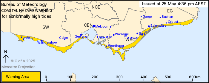
Abnormally High Tides expected for Victoria.
Weather Situation: A cold front will cross Victoria on Monday as an associated low approaches and then crosses Bass Strait during Monday night. On Tuesday that system will move into the Tasman Sea, and a ridge of high pressure to the west will direct a persistent cool southwesterly flow over Victoria.
ABNORMALLY HIGH TIDES which may lead to sea water flooding of low lying areas of all Victorian coasts. Tides are likely to rise WELL ABOVE the normal high tide mark during the afternoon and evening high tides on Monday and Tuesday. The highest tides are expected for Tuesday.
At the Cape Portland tide gauge, the sea level is forecast to reach above 1.6 metres. At the Lakes Entrance tide gauge, the sea level is forecast to reach above 0.9 metres. This is expected to cause sea water flooding of low lying areas.
Locations which may be affected include Warrnambool, Portland, Wonthaggi, Lakes Entrance and Mallacoota.
The Victoria State Emergency Service and Life Saving Victoria advise that people should be aware of the following:
- * Do not walk, ride or drive through flood waters.
- * Stay away from beaches, tidal rivers and creeks.
- * If you have a boat or water craft, haul out if possible or check your moorings are secure.
- * Keep away from flooded drains, rivers, streams and waterways.
- * Stay informed - monitor weather warnings and forecasts at the Bureau of Meteorology website, and warnings through VicEmergency app, website and hotline (1800 226 226).
Warnings are also available through TV and Radio broadcasts, the Bureau's website at www.bom.gov.au or call 1300 659 210. The Bureau and State Emergency Service would appreciate warnings being broadcast regularly.