Australia Weather News
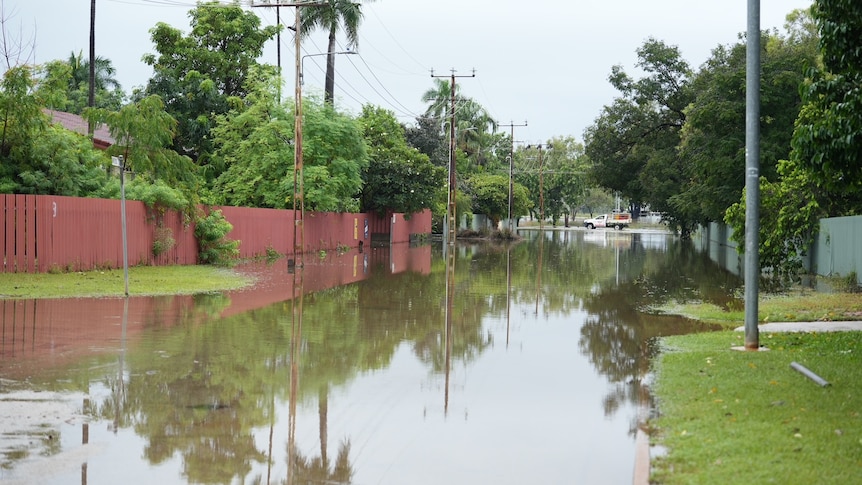
Renewed flooding is not currently expected in Katherine, but heavy rain could be on the way. (ABC News: Dane Hirst)
The Bureau of Meteorology is set to issue a cyclone watch alert for parts of the Northern Territory from Thursday morning, as residents attempting to clean up after devastating floods brace for more rain.
Tropical Cyclone Narelle is currently at category two strength and sitting about 950 kilometres off the Far North Queensland coast.
The Bureau of Meteorology's Jude Scott said NT communities likely to be impacted included Groote Eylandt, Numbulwar and Ngukurr.
"During tomorrow, the system will continue to move steadily west, intensifying to a category five system during Thursday, and then is likely to cross between the Lockhart River and Port Douglas in Queensland on Friday morning," she said.
"It will then move towards the NT coast in the Gulf of Carpentaria."
But while communities around Groote Eylandt and Borroloola brace for the biggest impact, authorities have warned that a large swathe of the territory could also feel the system's effects.
Live 5-day Cyclone Narelle forecast map
[cyclone tracker link]NT Fire and Emergency Services deputy commissioner Adam White said that includes communities and river catchments inundated in this month's floods.
"That message for getting ready goes all the way down the east coast of the NT, so all the way from Galiwin'ku all the way around the east coast to the border," he said.
"Then it continues all the way inland across the whole of the Big Rivers region to the Joseph Bonaparte Gulf over the coming days.
"It is an intense system, it's fast-moving and it will have widespread effects."
No renewed flooding is currently expected in the Katherine River.
But BOM senior forecaster Sally Cutter said forecasters are still modelling the system's path, which would determine how much rain falls in the Katherine catchment.
"It will most likely be a cyclone when it crosses the coast, and it will weaken out as it moves across the land," she said.
"It just depends exactly the path it's taking — [if] it goes between Katherine and Darwin … Katherine won't get the heavier rainfall.
"It really depends exactly where it goes and there's still a little bit of variation with the models."
Katherine officially transitioned to the recovery phase on Monday after last week experiencing its worst flooding in 28 years.
The Member for Katherine, Jo Hersey, said residents were worried about the forecast and keen to get more information.
"I know that everyone that I've spoken to is very nervous," she said.
"We will keep very closely monitoring [the situation] with the BOM and I urge people to keep [up-to-date through] Secure NT."
Late yesterday, Power and Water Corporation (PWC) said only a "small number" of properties remained without power, but that preparations are underway for further severe weather.
Weather puts NT health system under stress
On Tuesday, health authorities revealed the territory's three largest hospitals in Darwin, Palmerston and Alice Springs had made "code yellow" declarations, which are triggered when a facility is over capacity.
The declarations can mean the cancellation of some elective surgeries and moves to increase patient discharge.
An NT Health statement said the hospital system was experiencing "system-wide pressures … due to simultaneous and ongoing emergency responses to weather events."
Chief executive Chris Hosking told ABC Darwin that Royal Darwin Hospital was caring for patients evacuated from Katherine and residents of remote communities needing treatments for chronic disease.
"When we called the code yellow [at Royal Darwin Hospital], I think we had more than 20 patients double-bunked in emergency, every hospital bed was full," he said.
"We had taken over one ward in the private hospital in order to care for the patients extracted from Katherine, and there were still another 50 people waiting in the waiting room to be seen."
Mr Hosking said NT Health was asking medical staff in the wider system to volunteer to relieve hospital colleagues if possible.
NT Health said it urged people requiring non-urgent care to contact a GP or Medicare Urgent Care Clinic.
ABC