Australia Weather News
Tropical Cyclone Narelle is forecast to make landfall along the Far North Queensland coast on Friday as a category four system. (Supplied: Bureau of Meteorology)
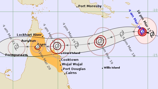
The third severe weather system in as many weeks is closing in on Far North Queensland as Tropical Cyclone Narelle pushes toward the coast.
The category two system is currently sitting just over 1,000 kilometres east-northeast of Cooktown and is expected to intensify to a category four cyclone before making landfall later this week.
It is moving west-northwest at 18 kilometres per hour.
The Bureau of Meteorology's (BOM) cyclone watch zone this morning stretches from Port Douglas to Lockhart River and includes adjacent inland areas.
[live tracker]'Rare system' to bring wide impacts
The cyclone is expected to steer steadily to the west, moving across Cape York Peninsula and through to the Gulf of Carpentaria into the weekend.
Conditions will deteriorate from Thursday with damaging wind gusts of up to 120km/h, starting with areas between Cape Melville and Port Douglas earlier in the day.
The affected area will then widen to include Lockhart River through the afternoon.
Destructive wind gusts of up to 155km/h are forecast for areas between Coen and Cooktown from Thursday night, with very destructive wind gusts of up to 200 km/h expected near Narelle's eye.
Tides will also be higher than normal between Coen and Port Douglas, with the BOM warning large waves could deliver minor flooding in some areas.
Heavy rainfall is also forecast.
[Link - datawrap]Totals of 200 millimetres are possible with isolated totals reaching about300mm on Friday, bringing a growing risk of flooding at waterways.
"Catchments are already quite saturated, rivers already have quite a lot of water in them," BOM senior meteorologist Baden Gilbert said.
"More rainfall can bring the risk of flash flooding."
Residents in the Lockhart River Aboriginal Shire Council have started standard cyclone preparations, including fuelling up heavy machinery for potential deployment.
Chief executive Dave Clarke said the community, 800km north of Cairns, was used to dealing with cyclones.
"One of the things our community is very, very good at is resilience," he said.
"Every year, between three and five weeks a year, our roads are cut off … so the isolation isn't an issue."
As the system tracks west, the BOM has predicted warm waters in the Gulf could cause the cyclone to re-intensify as it heads west towards the Indian Ocean.
"This could be a rare system that could end up impacting all of Far North Queensland, the top and northern and Western Australia," Mr Gilbert said.
Fishers fear seafood shortages
Meanwhile, fishing boats across northern Queensland are still docked two weeks into the fishing season, with rough conditions leading to concerns about a lack of supply in coming weeks.
Townsville fisherman and seafood retailer Lucas Dansie said the fishing industry had been watching the latest cyclone closely.
"Everyone is just sitting at the wharf and they don't really want to go to work because there is no incentive to risk your life and your boat as well as the expense of the fuel," he said.
With Easter only weeks away, he said there was a small window to bring back fresh produce to meet holiday demand.
"When everybody wants fish, you can't bloody get it," Mr Dansie said.
Mr Dansie has planned ahead and begun sourcing produce from south-east Queensland.
The Queensland Seafood Industry Association's David Bobbermen said prawns and reef fish could soon be in short supply.
Mr Bobbermen encouraged the community to think ahead and buy seafood early to avoid disappointment.
"Go and have a chat with your fishmonger now and put an order in now so they can guarantee it can be filled," he said.
ABC