Australia Weather News
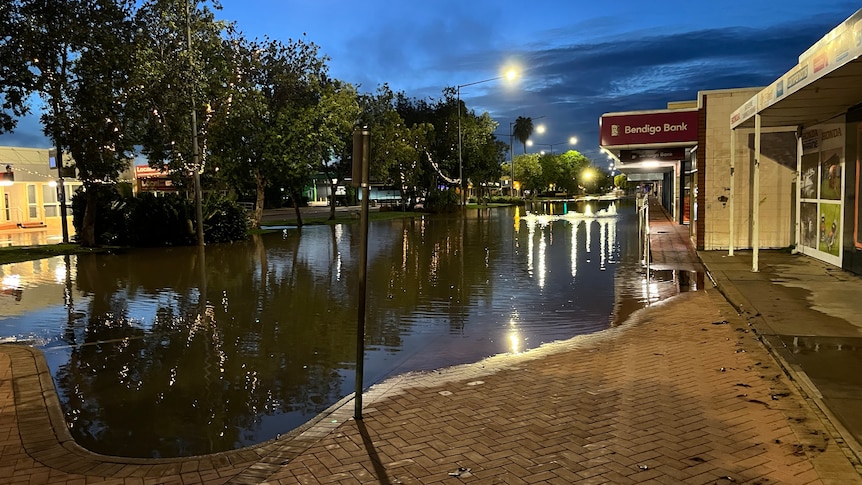
Floodwaters have spilled across parts of Katherine Terrace, alongside the Stuart Highway running through the centre of town. (ABC News: James Elton)
Authorities are warning "the whole of Katherine is under threat now", with "major flood risk" expected to remain over the Northern Territory town until Sunday.
NT incident controller Shaun Gill said two flood rescues were carried out in Katherine overnight "where people were trapped into houses".
There are no evacuation orders in place for Katherine, but Commander Gill urged residents concerned about their properties to sandbag if appropriate or move to an shelter.
"The flood conditions are only going to get worse in the short term," he said.
"The whole is Katherine is under threat now.
"I don't want to be overly specific on it but it's houses under threat, it's houses under water."
It comes as a tropical low hovers over large parts of the Top End this weekend, with Bureau of Meteorology (BOM) forecasting this wet season could become the 10th wettest on record.
Katherine River to peak at 19.2m
BOM's Shenagh Gamble said Katherine River was "slowly reaching a peak" with flood risk expected "to stay above major" levels until Sunday.
"So the Katherine community or township, is around 18.62 metres right now," she said.
"[It] is expected to reach a peak of 19.2 metres during tonight.
"Once those river heights have peaked, we expect it to stay above major at the Katherine community and township for about 24 hours, so we expect it to stay above major through the weekend into Sunday."
BOM said "major flooding above the April 2006 flood level" — when the river peaked at 19 metres — was occurring this morning at the entrance to Nitmiluk Gorge.
The Katherine River reached the major flood level yesterday, with BOM reporting floodwaters at Katherine Bridge passed 18.79 as of 11am today.
The expected 19.2 peak at Katherine River would likely submerge the town's high-level bridge.
The low-lying Aboriginal community of Miali Brumby, also known as Kalano, which is on the outskirts of Katherine has been cut off by floodwaters.
A significant number of buildings in the community have been surrounded by water and inundated on the ground floor.
Hundreds in shelters
Katherine's flood emergency warning was triggered yesterday, with the local hospital evacuated and closed, the Stuart Highway cut off and emergency shelters set up.
NT Chief Minister Lia Finocchiaro said although the hospital had closed, two "vulnerable people" remained at the facility and needed to be evacuated to Darwin.
On Friday, a temporary emergency department was stood up at the St John Ambulance NT headquarters on Chardon Street, which Mrs Finocchiaro said 20 people had already used for medical assistance.
Around 377 people across the Katherine region were sheltering in local schools as of this morning, and levees north of the town had been activated.
Shelters are open at Katherine High School and MacFarlane Primary School, both on Grevillea Street, and at Casuarina Street Primary School on the corner of Casuarina Street and Needham Terrace.
Local landscaper Ben Hockey has been up since well before dawn, frantically helping distribute sandbags to fellow businesses on Katherine's main street.
He's working alongside a small group of dedicated locals, but told the ABC they don't have enough sandbags or volunteers.
However, Mrs Finocchiaro assured the Katherine community there were more sandbags available, with two more truckloads of sand on its way and thousands of hessian bags prepared.
The local SES has been in touch with Mr Hockey to try to coordinate sandbagging efforts.
Palumpa, Daly River evacuated
The nearby remote communities of Palumpa and Daly River are being evacuated as a result of the extreme weather in the Big Rivers region.
Emergency flood warnings remain current for the Daly River, which is expected to reach major flood level on Saturday afternoon.
Commander Gill said six aircraft were now helping evacuate the remote community of Palumpa by air, with road access to the community cut due to rapidly rising floodwaters.
About 200 evacuees from Palumpa will be staying at Marrara Indoor Stadium in Darwin, while about 400 Daly River (Nauiyu) residents are expected to be evacuated to Foskey Pavilion at the city's showgrounds.
Locals in the remote Indigenous community only returned home late last month, after earlier rains caused Daly River to flood.
Meanwhile, flooding peaked in Beswick yesterday and was expected to fall below the major level this afternoon.
Moderate flooding in Beswick is expected to continue across the weekend, with an evacuation centre there — located on higher ground — opened to those in need yesterday.
Tropical low brings rainfall
BOM senior meteorologist Rebecca Patrick said the bureau was monitoring tropical low 31U, which had made landfall north-east of Katherine.
She said, while there was a "low chance" of the weather system developing into a cyclone, heavy rainfall across the Top End was possible.
"As we see that tropical low move from the Gulf of Carpentaria across the Top End, we might see an increase in rainfall," she said.
The BOM's track map shows 31U is expected to sit near Katherine today, stretch in opposite directions to cover Daly River in the west and the remote community of Ngukurr in the east — splitting the weather system in two — on Sunday, before it is forecast to reform and dump rain as far north as Batchelor and southern parts of Darwin tomorrow afternoon.
It is not the first tropical low over the past fortnight to bring heavy rainfall, with one stalling over Central Australia in mid-February before travelling further south last weekend.
BOM's Felicity Gamble told ABC Radio's Country Hour program earlier this week the "stationary system" had drawn in moisture from the north and dumped "very high rainfall totals" across the outback.
One of the NT's wettest seasons
Ms Patrick said the Top End had experienced "a fairly consistent and active wet season", while further south December and January in the NT had been "relatively dry".
But she said last month was a different story.
"We had a number of heavy rainfall events with thunderstorms, as well as that tropical low that moved southwards and sat around the south-eastern parts of the territory for basically the second half of February and dumped a lot of rainfall," she said.
"In the southern parts of the NT, we've seen rainfall more than four times the amount that we'd normally see in February.
"Across northern Australia, it is tracking as our 10th wettest wet season on record."
With March expected to continue bringing "above-average rainfall", she said the season could still progress to a higher place on that record ladder.
ABC