Australia Weather News

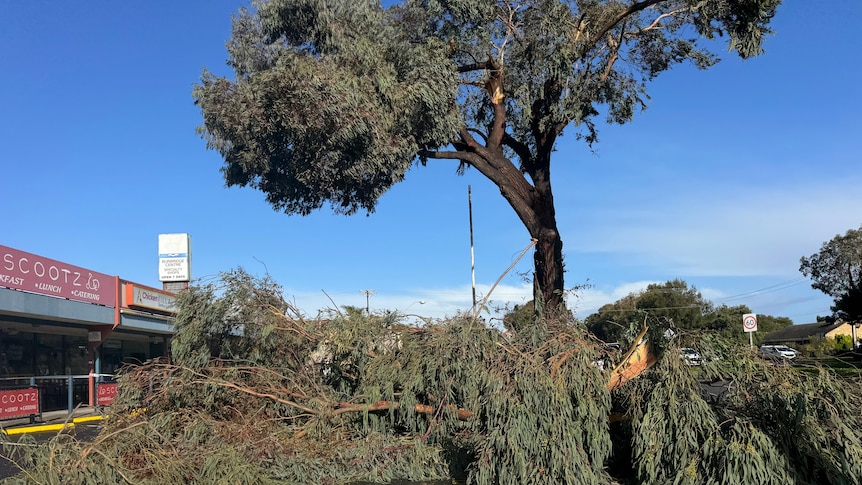
The State Emergency Service SA respond to 160 jobs on Friday morning, mostly of fallen trees. (ABC News: James Wakelin)
Destructive winds sweeping across South Australia has damaged roofs, fences and has caused power outages as a "rare" tornado warning was issued on Friday morning.
The Bureau of Meteorology has issued a severe weather warning for Adelaide, Mount Lofty Ranges, Eyre and Yorke peninsulas, Flinders, Mid North, Kangaroo Island, Riverland, the South East and parts of West Coast, North East Pastoral and North West Pastoral districts.
It sent out a "rare" tornado warning for Adelaide's northern suburbs and parts of the Adelaide Hills earlier this morning, but has since said "the immediate threat" has passed.
Meteorologist Daniel Sherwin-Simpson told ABC Radio Adelaide some parts of the state had experienced wind gusts in excess of 100 kilometres per hour on Friday morning.
"We have seen some of those severe thunderstorms developed so it is possible that these could result in some tornadoes in areas in that sort of destructive wind area covered by the severe weather warning," he said.
"[Tornadoes are] pretty rare and the warning comes out very rarely because it's only once we have a good guidance that this could happen."
He said the tornado warning was linked to "two particular thunderstorm cells", which have since eased.
The bureau has forecasted damaging winds of 60 to 70kph, reaching peak gusts of100kph, for Friday.
Wind speeds of 106kph were recorded at Outer Harbor, and the bureau has warned the lower South East coastline could experience gusts of 115kph on Friday afternoon.
The State Emergency Service SA State Duty Officer Kane Murray said they responded to 160 incidents this morning.
"There have been a few people that have had parts of their roof removed, tiles and sheeting," he said.
"There's some fencing around some properties that's been blown over, but a lot of those tasks are trees down."
An Elizabeth resident, Raymond, told ABC Radio Adelaide he was pulling out of his driveway when a fallen tree narrowly missed him in an incident he described was like "a mini tornado".
"It took out the front windows of our house, all the tree branches hit the front window, took out the tiles on our roof," he said.
"It just would have been on top of my car if I hadn't slammed it into drive, went forward into the carport again."
More than 4,000 Adelaide metropolitan residents are without power, while there have been reports of foamy water along West and Henley beaches.
Senior meteorologist Mark Anolak said there was a slight chance of "snow flurries" in the Mid North, the southern Flinders and in the Adelaide Hills.
He said hail and thunderstorms would accompany heavy rain on Friday, particularly in exposed coastal areas.
Cold front move across SA
On Thursday, meteorologist Jonathan Fischer said "a blast of cold air" caused by an intensifying low-pressure system was expected to move across the state.
"That low is also going to direct quite a powerful cold front across southern parts of South Australia from early Friday morning," he said on Thursday.
"Not only will it be quite a wet day, a cold day, across South Australia — the major concern is damaging, and even locally destructive, winds.
"It's not your standard wintertime cold front — we don't see this type of conditions every week in winter."
State Emergency Service chief of staff David O'Shannessy said residents should secure loose items around their homes and avoid parking under trees.
"If these locally destructive winds are experienced, they absolutely have the capacity to cause significant damage," he said.
ABC