Australia Weather News
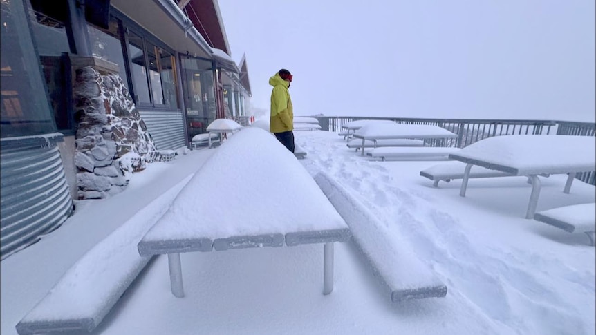
Mount Hotham was already under a blanket of fresh snow on Thursday, with another 24 hours of heavy snow still to come. (Supplied: Mount Hotham Resort)
An intense polar outbreak will bring one of the most widespread snow events in years to south-east Australia during the next 24 hours.
With air arriving directly from Antarctica, the system could even bring flakes within 35 kilometres of five capital cities.
While snow is a welcome novelty in many areas, the winter storm will also generate gale-force winds and the potential for damage and power outages in multiple states.
When and where snow will fall
What separates this event from a regular winter storm is the air mass surging north towards Australia that originated along the Antarctic coastline, as opposed to the Southern Ocean.
The coldest air will cross South Australia on Friday evening, and could bring snow above an elevation of 800 metres on the Southern Flinders Ranges, and above 700m on the higher Mount Lofty Ranges.
The polar air will then sweep across eastern states overnight, dropping the snow level to around 600m in Victoria, 700m in NSW, and 300m in Tasmania.
With such a low snow level, flakes are likely on the doorstep of Canberra, Hobart, Melbourne, Sydney and possibly Adelaide.
Here is a city-by-city breakdown of the closest likely snowfall to our capitals:
Snow to blanket the Great Dividing Range
Along with the snowfalls near our capitals, dozens of regional towns and cities could also wake to a blanket of white on Saturday morning.
In NSW, this includes Orange, Lithgow, Oberon, the Monaro towns, and possibly even around Bowral and Goulburn, plus the northern towns of Guyra and Walcha.
For Victoria, snow is likely around Trentham and Omeo, but a dusting should stretch right along the Grampians, and potentially the highest peaks of the Otway and Strzelecki ranges.
For alpine regions, snow has already been falling for nearly 48 hours — and with another 40 centimetres likely on Friday into the night, the storm total could near 1m on the higher slopes.
Across Tasmania, snow will drop to near sea level overnight, although a repeat of the 2015 event which brought snow to Hobart's beaches is unlikely.
The majority of the snow will have cleared by mid-morning Saturday as the polar air mass moves off the east coast.
However, temperatures will remain cold enough through the afternoon to sustain the cover for higher regions until at least Monday.
Other wintry precipitation from the icy blast includes small hail which is possible across southern NSW, agricultural SA and through Victoria.
Risk of power outages from fierce gales
Along with snow, the cold outbreak will also bring fierce winds, which will down trees and possibly lead to power outages in multiple regions.
Fronts midweek have already generated gusts to around 100 kilometres per hour in eastern NSW, however a deep low pressure system associated with the upcoming winter storm will broaden the threat.
Peak wind gusts from 90 to 100kph are predicted by the Bureau of Meteorology across much of SA, Victoria and NSW during the next 24 hours — strong enough to bring down tree branches and possibly topple trees.
A more intense burst of gusts of about 110 to 115kph is also likely near the centre of the deep low as it tracks east through Bass Strait, spreading from the south-east coast of SA on Friday afternoon, to the Victorian western and central coast tonight, followed by Gippsland early Saturday.
Winds of this intensity are capable of causing roof damage, downing large trees and causing trampolines to go flying.
However, the presence of storms could briefly enhance winds even further in parts of SA, regional Victoria and the Riverina — including localised destructive gusts closer to 130kph, the equivalent of the strength of wind in a category two tropical cyclone.
Combined with heavy snow, the gales' white-out conditions will develop across alpine areas, triggering a blizzard warning above 1,200m.
Another impact of the wind is bitterly cold apparent temperatures, which will plummet around 10 degrees Celsius below the ambient air temperature.
For example, while Adelaide is forecast to reach 13C on Friday, the warmest it will feel should be closer to around 5C.
Sydney is predicted to reach 17C on Saturday, but factoring in the wind, people should dress for temperatures below 10C.
ABC