Australia Weather News
The weather bomb has the potential to generate a combination of heavy rain, gale force winds and damaging surf. (ABC News)
Forget the headlines and hyperbole of the fictitious "rain bomb", the real weather bomb — a rapidly intensifying low-pressure system — is possible along Australia's east coast next week.
The winter storm may even become the first East Coast Low (ECL) in three years, and has the potential to generate a combination of heavy rain, gale-force winds and damaging surf.
And while New South Wales is currently the likely focus of severe weather, impacts from the system will be felt down the coast to eastern Victoria and as far north as tropical Queensland.
Explosive formation in 24 hours
When a low-pressure system transforms from non-existence to a formidable storm just a day later, meteorologists label it a "bomb cyclone", or a system that has experienced "bombogenesis".
The expression "bomb" is due to the explosive speed of development, however its usage is restricted only to systems where the reduction in pressure exceeds a specific rate based on latitude.
For the Tasman Sea, the drop in central pressure required in a 24-hour period ranges from 18hectopascals (hPa) near Tasmania to 14hPa near the Queensland-NSW border.
Next week's low is predicted by modelling to deepen between 22hPa and 24hPa in a day — easily passing the weather bomb criteria.
Considering the above definition is based solely on pressure, the nonsensical term "rain bomb" becomes an irrational fallacy, lacking any scientific validity.
Rain and gales to start in July
The first signs of the upcoming storm will arrive this weekend at opposite ends of the country.
Patchy rain will form over north Queensland from a band of tropical moisture, while in the south, light showers will spread through Tasmania, Victoria and South Australia under a tongue of polar air.
The two contrasting systems will then collide on Monday near the east coast, leading to the initial drop in pressure and increasing showers from central Queensland to Sydney.
As the low becomes fully developed on Tuesday along this volatile air mass boundary, the weather will rapidly deteriorate near its centre.
Another influence that could enhance the system is the current warmer-than-normal water temperatures in both the Coral and Tasman seas — not only a source for moisture and rain, but also a factor that will amplify the warm/cold contrast.
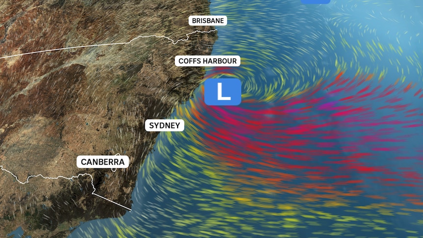
While it looks inevitable this low will become formidable, the impacts felt along the NSW coast are highly dependent on its exact position.
An intense low tracking near the coast is likely to produce a combination of heavy rain, damaging winds and powerful surf, with the worst weather near and to the south of the centre where winds are onshore (remembering winds spin clockwise around a low).
Under this coastal scenario, hundreds of millimetres would trigger both flash and river flooding, although it is too early to pinpoint which catchments are at the greatest risk.
Below is a five-day rain forecast map showing how much could fall if the low tracks down the NSW north coast, which shows a bullseye of about 200mm, or around double the July average rainfall in 48 hours.
Gales also pose a significant threat, with gusts near 100 kilometres per hour downing trees and leading to power outages along the coast and ranges.
A low 200km to 400km offshore would lead to less widespread severe weather, while a position around 500km off the coast may only bring strong winds and showers but with minimal if any adverse impacts from wind or rain.
What is more certain, irrespective of the low's position, is huge waves will pound the coast.
Current modelling shows average heights reaching about 5 to 6 metres, including Sydney, which equates to maximum waves about 10m and a threat of significant coastal erosion.
First East Coast Low in three years
The upcoming Tasman low, along with being a "bomb cyclone", has the potential to become the first ECL since 2022.
The criteria used to distinguish ELCs from other Tasman lows are?
With the exception of rare southern tracking tropical cyclones, ECLs are the most significant weather systems to impact south-east Queensland and eastern parts of NSW, Victoria and Tasmania.
Surprisingly though, despite numerous flood events along the east coast during the past 18 months, none have been associated with a true ECL.
A forecasting nightmare
Deep Tasman lows near to the coastline are notoriously difficult to forecast with precision, even only a day or two ahead.
The systems stand out for their rapid development, intensity and modelling inaccuracy, especially compared to other less dynamic mid-latitude weather features like high-pressure systems and cold fronts.
In addition, the exact location and intensity of an ECL is more critical than a typical high or low since dangerous weather is normally confined to a relatively small area south of the centre.
The consequence of this concentration of hazards is a minor forecast error that could be the difference between a region having no severe weather or hundreds of millimetres of rain and gale-force winds.
This sharp gradient of intensity was apparent during the August 1986 ECL — Sydney was hammered by a record 328mm of rain in 24 hours, while just 50km north, parts of Gosford received less than 50mm.
ABC