Australia Weather News
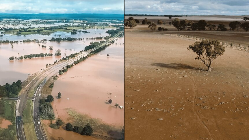
The end of May saw severe flooding in NSW's mid-north coast, while parts of South Australia and Victoria were in a record drought. (NSW Police/ABC News: Jess Davs)
There are signs a major climate driver could shift into its "wet phase" over the coming months, boosting the chance of rain across large parts of Australia toward the end of winter.
The Bureau of Meteorology (BOM) has released its official outlook for the season ahead.
It shows strong signs that winter will be warmer than normal, continuing on from what has been a record-warm start to the year for large parts of southern Australia.
But, for many, it's the rain that will matter the most, with southern parts of the country in the grip of severe drought, while flooding devastated parts of the east.
Wait for the rain could stretch on
Unfortunately, the long-range forecast offers few clues on what is to come for the next two months for the regions that rely on winter rainfall.
Across June and July, the model slightly favours wetter-than-normal weather through flood-affected parts of the east coast and some drought-affected parts of South Australia.
But for most of Australia's populated areas there is no clear sign that rainfall will veer from the average.
"What we're really saying is the dice aren't particularly loaded over the next three months for either wetter or drier conditions," BOM's national manager of climate services Karl Braganza said.
There is, however, a notable shift later in the season, with the rainy signal strengthening for large portions of the country from July to September.
This signal is strongest through northern and central parts of the country, but also extends through the majority of Queensland, into New South Wales away from the coast, and across much of South Australia.
Dr Braganza said this was consistent with forecasts that a major climate driver — known as the Indian Ocean Dipole — would swing into its wet phase over the coming months.
The Indian Ocean Dipole — or IOD — is often referred to as the cousin of the better-known El Niño and La Niña.
During a negative phase, warmer-than-normal waters concentrate near Australia's north-west, helping to create a moisture-rich atmosphere that the western winds can tap into as they move across the country from the north-west to the south-east.
"So, for the last couple of years now, we've had just really warm waters around the coast of Australia," Dr Braganza said.
"And we've seen that with some of the rain-bearing systems that we've had come through. They've tended to rain a lot, including the recent system that we had in the east over New South Wales.
"So those warm oceans are having an influence on the east of the continent, and they're having an influence over the north-west and inland parts of the continent as they bring moisture over the mainland."
Southern Australia desperate for rain
In South Australia and western Victoria, rain is desperately needed soon, according to agronomist Martin Colbert.
"We need above-average rainfall immediately just to get the crop to start," he said.
"If we get sub-average rainfall before spring, things will be so that poor that, while rain will be nice, it won't save us."
Unfortunately for drought-stricken parts of western Victoria, the prospect of above-average rainfall remains inconclusive even into the later part of the season.
It is the same for large parts of Western Australia and Tasmania, which have also been overwhelmingly dry and warm for the past year.
The ongoing dry conditions have forecast an unseasonal increased fire risk through large parts of South Australia and Victoria this winter.
"At this time of year, typically you don't get the really high temperatures, low humidity and wind speeds that cause a fire to rapidly spread," Dr Braganza said.
"So it's quite different to summer, but it's very dry out there with dry paddocks and other things. So grassfires and other fires could get going at this time of year."
Another warm winter
One thing that is clear in the winter forecast is the temperature.
The entire country is strongly favoured to have warmer-than-normal day and night-time temperatures this season.
Warm winters are something that have become commonplace in recent decades. Of the 10 warmest winters on record, nine have occurred since 2010.
[Chart winter temp anomalies]"So that just really emphasises how our climate is changing," Dr Braganza said.
Warmer-than-normal weather overall does not mean it will necessarily feel warm, however. Nor does it mean it will be warm all the time.
Last year, for example, was Australia's warmest winter on record but featured several days where the mercury plummeted to freezing levels.
Forecast not set in stone
Dr Braganza said the bureau's long-range model represented "conditions at the largest scale", such as pressure patterns and ocean conditions.
But it cannot pick up on individual systems and how much rain they will bring.
These individual systems can make a big difference to the outcome.
Australian National University hydro-climate scientist Chiara Holgate said studies of past droughts in southern Australia had shown the presence of just a "handful" of big, organised storms could be the difference between a wet and dry season.
"We know from other studies that it's a handful of the heavier rain days, say about 10mm in a day, that can change the fortunes of a region of Australia," Dr Holgate said.
"So if there's 10 extra days compared to normal of those higher rain days, we can expect it would be a wet year. But if we didn't get those 10 or so heavy rain days, then that region would be at risk of entering drought."
ABC