Australia Weather News
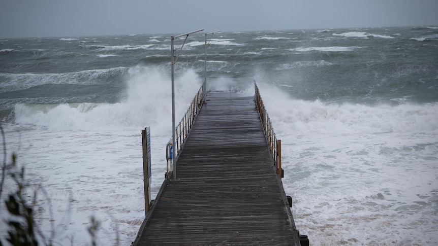
Waves lash the jetty at Henley Beach amid wild weather. (ABC News: Lincoln Rothall)
Parts of South Australia are undergoing their first burst of wet weather in months, with the wild conditions causing power outages, fallen trees, flash flooding, rough seas and a cancellation of Kangaroo Island ferry services.
The Bureau of Meteorology (BOM) has warnings in place for much of SA, while the State Emergency Service (SES) has advised of the increased risk of downed powerlines and fallen trees after months of drought.
"With this extended dry period, we've got plenty of stressed trees, so there's an increased risk of branches falling and becoming loose," SES state duty officer Brad Flew said.
"We're asking people to steer clear of trees and not to park under them if possible."
Mr Flew said the service has had about 30 call-outs for minor flooding, mostly through skylights.
"Destructive winds are one of main concerns at the moment in the greater Adelaide area … where we might see some tree damage," he said.
Electricity has been cut to several thousand homes and businesses, with many of those outages caused by the wild weather.
One of the biggest is in the Marion area, where more than 900 customers were left without power.
A severe weather warning for "damaging, locally destructive winds" has been issued for much of the state including Eyre and Yorke Peninsulas, the Mount Lofty Ranges, Adelaide metropolitan area, Flinders, Mid North, Kangaroo Island, Murraylands, Riverland and south-east.
There are also gale and strong wind warnings — and a coastal hazard warning for abnormally high tides — for stretches of the state's coastline.
South Coast surfer Anthony Rowland said he woke to strong winds before "deep rolls of thunder" came in this morning.
He said at Middleton, the water was "lapping right up against the vegetation on most of the beaches down here".
"I watched the first front move over Victor Harbor and it absolutely unleashed a huge downpour on us. We even got some hail," he said.
"In that first hour we got close to 18mm at my house, in my weather station — then the sun came out so there were some pretty spectacular rainbows.
"And then another little squall came over the top."
Flash flooding has occurred at several spots, including in classrooms at Victor Harbor Primary School.
"The school is grateful for the assistance of the SES and local MFS who provided assistance, and support with some preventative sandbagging in anticipation of more rain in the area," an Education Department spokesperson said.
"Students have been moved to alternative classrooms for the day."
Heavy downpours around Yankalilla and Normanville led to water covering the road.
On the beach at Normanville, a pontoon which was the source controversy over summer has been swept back onto the beach.
Kangaroo Island ferry operator SeaLink said its early morning services from Cape Jervis and Penneshaw had been cancelled today, and that conditions would be monitored before a decision was made about tomorrow's services.
"Unfortunately, due to weather conditions matching the current forecasts and with increasing winds and high swells predicted throughout the day, all sailings for today, 26 May will not be operating," the company posted on Facebook.
BOM senior forecaster Simon Timcke said between six and 20 millimetres of rain were expected over Adelaide, and between 20 and 40 millimetres in the hills.
"The prevailing winds will be pretty strong and gusty, but the showers and possible thunderstorms will increase those wind gusts, I think, so they'll produce the gustiest winds and the most likely chance of any damage," he said.
"[We're expecting] certainly the wettest day we've seen for a while."
Port Adelaide Enfield Mayor Claire Boan said the council was on "high alert" along the stretch of coast between Semaphore and Birkenhead because of the high tide expected to hit.
She said staff were out this morning clearing areas and making sure sandbags would be available if required.
"We're expecting [flooding] to come from the high tide, in terms of the risk to properties, so that gives us a little bit more time to understand what is happening," she said.
"We'll be blocking off some beach entry-ways … especially at Semaphore South.
"That's an area of high risk just because of where the tide comes up closer to the foreshore."
Mr Timcke said while the system had "taken a little bit longer" to arrive "than we originally thought", the conditions were being caused by a low pressure system south of the state.
"There's a couple of pretty vigorous fronts extending from that low," he said.
"It looked like we'd probably start to see the showers very late Sunday evening or through the early hours of Monday morning but it has been a little bit slower to reach the Adelaide area."
The SES said it had received calls for assistance across the state, and urged the public to secure loose items.
"From Coffin Bay to the lower south-east we've had call-outs this morning," Mr Flew said.
"We're expecting some extreme weather, and some coastal conditions that are less than favourable.
"We're obviously experiencing high winds, a significant increase in wave activity, and we're expecting much higher tides than we're used to seeing."
ABC