Australia Weather News
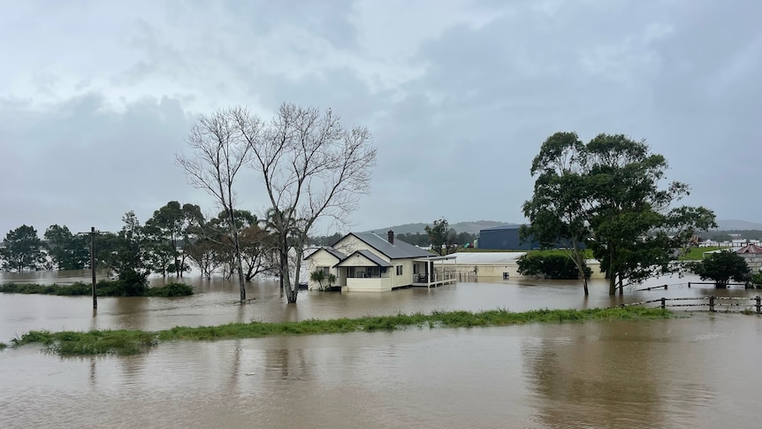
About 9,500 properties are in the direct vicinity of the floodwaters. (ABC News: Nakita Jager)
Just two months after Cyclone Alfred caused widespread flooding across NSW, the state is once again besieged by floodwaters.
On Thursday morning, there were 140 flood warnings for NSW, with 50,000 people being told to prepare to evacuate.
A man in his 60s lost his life in floodwaters in Moto, near the town of Coopernook on the Mid North Coast.
On Thursday afternoon, police confirmed the body of a man in his 30s had been discovered in floodwaters in the region.
Acting NSW Police Commissioner Peter Thurtell said there were "grave fears" for two other people.
Here is the extent of the flood-affected areas shown in three maps.
Heavy rainfall centred on the Mid North Coast
Senior meteorologist Angus Hines from the Bureau of Meteorology (BOM) said it had been an extremely wet night in the north of the state.
"Carrying into yet another wet day across the Mid North Coast and the northern Hunter, which of course are the districts that have been hit hardest by this prolonged rain event," he said.
He said some weather stations had recorded 300 millimetres of rain in the last 24 hours, taking the total to 500-600mm for the week so far.
Below are some of the weather stations that have recorded high rainfall totals in the last 24 hours.
ABC News meteorologist Tom Saunders said the 329mm at Moparrabah, inland from Kempsey, was the heaviest rain in at least 25 years for any month.
The 337mm in Bellingen was the heaviest May rain since 1977, he said.
[Insert rainfall map]There is some relief in store, with the BOM forecasting the rain will slow down on Thursday afternoon and Friday.
"Much of the wettest areas in the north-east of the state will see the worst rain today, much dryer from tomorrow," Mr Hines said.
Flooding stretching from Northern Rivers down to Hunter Valley
Areas of the state under flood warnings reach from Grafton in the Northern Rivers, all the way south to the Hunter Valley.
State Emergency Service (SES) Commissioner Michael Wassing said the threat could extend to Sydney.
Areas in the southern part of the Inverell area and around Armidale, are also affected.
The SES is advising there could also be minor flooding on the Warrego and Darling rivers in the north-west of the state.
[Insert flood map]Residents in 20 areas told to evacuate now
The SES has issued 134 emergency warnings as of 10am Thursday, ranging from "shelter now" to "move to higher ground" and in 20 areas, to "evacuate now".
The map below shows that the area around Kempsey is at the greatest risk, with six "evacuate now" warnings.
[Insert evacuation map]NSW Premier Chris Minns urged residents to steer clear of flooded roads.
"We need people to use common sense, to listen to emergency broadcasts, and not put themselves in harm's way. There is 140 flood warnings, 50,000 people are in the range where they have been asked to prepare to evacuate and could be isolated," he said.
He said there were 9,500 properties in the direct vicinity of the floodwaters.
ABC